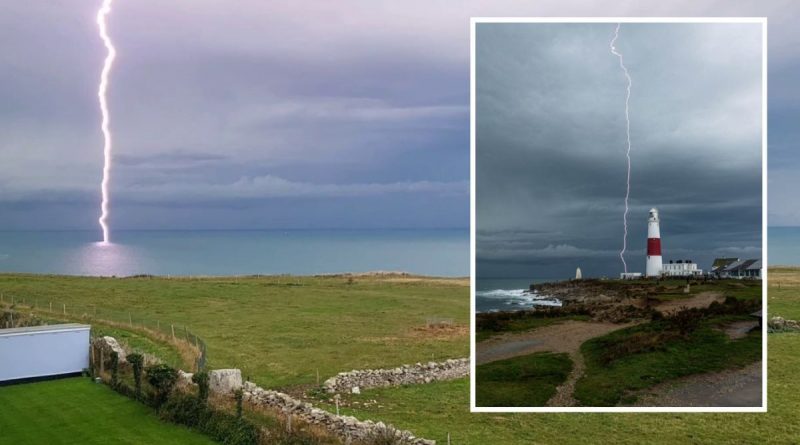
Terrifying and rare lightning bolt slams into the sea off UK coast
UK Weather: Yellow warning ahead of thunderstorms
We use your sign-up to provide content in ways you’ve consented to and to improve our understanding of you. This may include adverts from us and 3rd parties based on our understanding. You can unsubscribe at any time. More info
A dark sky blanketed much of the West Country over the weekend as a Met Office thunderstorm warning was issued. But no one could predict the extremely rare phenomenon which took place off the coast of Dorset. A lightning bolt struck the English Channel on Sunday afternoon at around 3.15pm and has been captured in a series of dramatic pictures. According to NASA, despite 70 percent of Earth being covered by water, only a measly 2 percent of lightning strikes occur over water.
The pictures were taken from footage which had been filmed in Portland. It shows a massive arc of lightning hit and light up the stormy seas, narrowly missing Portland Bill lighthouse.
Dorset was battered by thunderstorms and a band of heavy rain overnight on the weekend as the Met Office warned of widespread storms across much of the country, with potential flash flooding and power outages.
The bolt, despite hitting the sea, was relatively close to land – and according to experts at NASA there is a reason for this. It’s apparently because deep oceans are less likely to be hit.
This is why, in this extremely rare instance, the bolt was captured by onlookers who saw it striking a relatively ‘shallow’ part of the Channel.


Despite it being an irregular sight, the last time a thunderbolt hit the sea was actually only a few months ago. It happened during peak storm season for the UK, in July, amid the scorching temperatures that ravaged the country.
The weather had gone from one extreme to another – and in Penzance, Cornwall, a large bolt smashed against the sea. This second lightning sea strike marks the second official – reported – sighting in three months.
According to the Met Office, when lightning strikes venture further to shore – such as on a beach, or sandy soil, it fuses together the grains to create a small glass-like tube known as a fulgurite.
They are not only prized by collectors, they are also of great scientific value in demonstrating past occurrence of lightning storms.


While much of the West Country is now recovering from a rain-pelted weekend, the forecast for this week is very mixed – with Tuesday bringing sunny spells and a risk of showers, with more cloud increasing from late afternoon.
Then, stronger winds and rain will set in tomorrow evening – but this will not affect the mild 18C highs many towns in the south west have been experiencing.
Looking towards the latter end of this week – the Met Office says there will be more unsettled conditions with some increased windy weather – but it’ll remain mild for the time of year.
There is no mention of any further thunderstorms.
DON’T MISS:
Thatcher statue in Grantham defaced with ‘Tories out’ paint [REPORT]
Meghan and Harry slammed for Netflix ‘vanity project’ [INSIGHT]
Councils considering cutting bin collections to help climate change [ANALYSIS]
The weather outlook for the rest of the month is as follows: “This period is likely to continue to bring changeable and often unsettled conditions for many. Showers or longer spells of rain are expected to push north through the day on Friday, with the wettest weather affecting western areas, and a chance of some heavier bursts or isolated thunderstorms.
“Across the east it could stay mostly dry. Remaining unsettled over the weekend and for the rest of the period, with showers or periods of rain for many, most frequent and heavy in the northwest.
“Windy at times, with a chance of gales in the west. Temperatures likely to continue to be mild overnight and warm during the day, trending above normal for this time of year.”
Source: Read Full Article

