Thunderstorm and wind on the way with yellow weather warnings issued
Thunderstorm and wind on the way with yellow weather warnings issued as miserable start to August continues fears of a summer washout
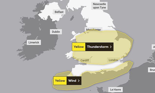
- Met Office has issued yellow weather warnings for parts of England and Wales
Thunderstorms and winds are expected to hit the UK tomorrow as fears grow that August could be another miserable month of rain.
The Met Office has issued a yellow weather warning for thunderstorms across the English midlands and Wales, while a yellow warning for wind has been issued along the southern coast.
The forecaster said that there will likely be ‘some damage to a few buildings and structures from lightning strikes’ during thunderstorms, which may also cause delays to train services and ‘short term’ power losses.
Meanwhile high winds of up to 60 mph are expected to cause delays to road, rail, air and ferry transport, with large waves likely to be seen along the coast.
The miserable weather will add to people’s fears that the country may be headed into an early autumn as temperatures this month could struggle to climb above 20C, according to the Met.

The Met Office has issued a yellow weather warning for thunderstorms across the English midlands and Wales, while a yellow warning for wind has been issued along the southern coast

The forcaster said that there will likely be ‘some damage to a few buildings and structures from lightning strikes’ during thunderstorms, which may also cause delays to train services and ‘short term’ power losses

The miserable weather will add to people’s fears that the country may be headed into an early autumn as temperatures this month could struggle to climb above 20C, according to the Met
The Met Office said: ‘Unseasonably windy conditions, accompanied by showers or longer spells of rain, will affect southern England and Wales during Wednesday.
It added that the highest winds will affect the Isles of Scilly and Cornwall and will spread into other English Channel coastal areas during the morning.
Up to 55-60 mph are expected to hit the ‘most exposed spots’ in the far south and southwest of England, while other parts of the coast will see speeds of between 45-50 mph. Winds are expected to slowly ease later in the afternoon.
The Met Office warned yesterday that the prospects for any ‘prolonged dry and hot spells’ this month are currently unlikely.
This week is expected to see more unsettled weather with rain, showers, stronger winds and cooler temperatures.
Into August, the country is likely to see thunder, sunshine and showers, with temperatures likely to be mostly below average, forecasters predict.
This is in spite of a series of blistering heatwaves in other countries making July set to be the world’s hottest month on record, sparking renewed warnings about the impact of climate change.
But in a glimmer of hope for anyone planning a domestic holiday over the next few weeks, forecasters say we may manage some short periods of sunny weather in the second half of August.
The reason for the glum weather continues to be the jet stream, which remains stuck across the British Isles – sending rainy Atlantic weather systems directly our way, just as it locks popular Mediterranean holiday destinations into heatwave conditions.
Source: Read Full Article