UK frost forecast: SUB-ZERO wind chill and dense fog to blanket Britons in hours –new maps
BBC Weather: UK warned of fog and frosty conditions
We use your sign-up to provide content in ways you’ve consented to and to improve our understanding of you. This may include adverts from us and 3rd parties based on our understanding. You can unsubscribe at any time. More info
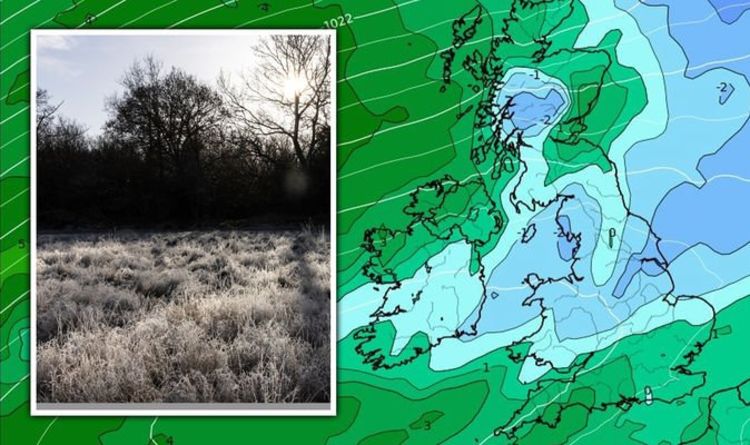
Despite warmer weather throughout the daytime this week, forecasters have said overnight conditions are set to be cold enough to leave frost and fog. Minimum temperatures are expected to be close to 0C, according to maps and charts.
WXCharts sees overnight temperatures will drop to 1C in much of Britain on Tuesday night.
By 9am on Wednesday, temperatures will stay at 1C in England and Wales, while Scotland’s sees comparatively warmer weather at 5C.
Windchill will see the country feel even colder in the morning, with it feeling around -1C for much of the UK.


The Met Office’s forecast for Tuesday night holds there will be frost overnight.
They said: “Windy across northern Scotland, with patchy rain and fairly mild.
“Elsewhere dry, patchy cloud in some central and western parts but clear elsewhere with frost and patchy rural fog.”
The agency added that Wednesday will see some fog, saying: “Southern and central areas mostly sunny with light winds, after any fog clears, temperatures mostly near average before frost and fog returns after dark. Northern Scotland, windy with patchy rain.”


Terry Scholey, Netweather.tv forecaster, said: “Cloudy, damp weather eventually clears from East Anglia and the South after dark to leave clearing skies.
“This’ll lead to a colder night as pressure rises strongly over much of England and Wales. Here there’ll be a slight frost with patchy mist and fog forming towards morning in light breezes, as temperatures fall to between -2 and +4C depending on cloud cover.
“Over the North and West of Scotland and Northern Ireland, it’ll be milder with a South West wind continuing to bring a few showers to the far North, where the thermometer may not fall below 8 or 9C.
“With a large anticyclone dominating, particularly in the South, most parts tomorrow remain settled and dry. The exception will be Scotland, where a southwest wind will be fresh in the North, bringing cloud and mostly patchy rain to these parts.“

Met Office forecaster Alex Deaking said: “In Scotland and Northern Ireland there’s a hint of blue on the charts and so certainly in rural areas and hills there will be pockets of frost.
“Most towns and cities just about staying above but we are in the colder air here further south with the cloud and the rain we are a long way from freezing with town in the south west perhaps staying in double digits.”
Monday was a washout for much of the country with plenty of rain but Tuesday should be brighter and then the mercury will drop again in the evening.
“Temperatures will tumble on Tuesday evening so again that blue hue on the charts suggesting frost before midnight in the Midlands, South Wales and further south will see a frost developing and some fog patches which could be slow to clear on Wednesday,” said Mr Deakin.
“More clouds across the North West and the Highlands but for most Wednesday is a fine winters day with some sparkling sunshine and light winds. Start with a frost but by the afternoon temperatures ticking up to about the average of 7C or 8C.”

While most forecasters hold “settled” conditions will prevail over January, the Met Office’s outlook for the end of the month sees a return to wet and cold conditions.
They said in a forecast from January 25 to February 8: “A more unsettled regime is most likely during late January and into early February with spells of wet and windy weather followed by brighter but showery interludes.
“Northwestern areas are likely to be wettest with southern and eastern areas seeing the best of any drier interludes.
“Overall temperatures are most likely to be near or a little above average though some colder interludes are possible.
“Snow could fall to lower levels at times in any colder interludes but is most likely over higher ground in the north.”
Source: Read Full Article


